Bentley Systems subsidiary releases free digital map of US interstate infrastructure assets
25 November 2024
Blyncsy, a Utah, US-based subsidiary of Bentley Systems – a software technology company serving the design, construction and engineering industries – announced it has developed and released (for free) a near real-time digital map, which logs infrastructure assets across the US interstate highway system.
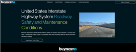
 The homepage of Blyncsy’s digital road-assets map. (Screenshot from Blyncsy.com)
The public map was gathered via a network of dashboard cameras and sensors, with software using the images to input and catalogue items like guardrails, speed limit signs and work zones.
Users can navigate assets via a continental display of the US, or they can access and request data for specific states and regions.
“When coupled with Blyncsy’s powerful AI image analysis toolset, [the cameras] can detect over 40 different road conditions and asset inventory issues in near-real time. These issues include potential roadway safety hazards from guardrail damage, missing signage, and lack of proper road striping to roadway vulnerabilities from crashes, natural disasters and work zone areas,” said Blyncsy.
The company believes its system provides an advantage over similar scanning and surveying techniques particularly when “compared to other manual data collection technologies like LiDAR, or traditional road inspection methods, which require road maintenance crews to be dispatched.”
Putting together Blyncsy’s digital road-asset map
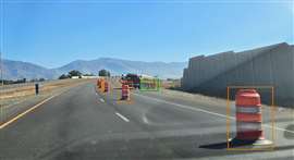
 A sample photo from the crowdsourced images that are mapping US interstate road assets from coast to coast. (Image: Blyncsy)
Blyncsy CEO Mark Pittman told Construction Briefing the idea was born amid a conversation on “digital infrastructure”.
“It’s this buzzword that we’ve been talking about for a couple of years now,” said Pittman. “What’s become clear to me is that we’re talking up a big game, but no one’s actually doing anything.”
That reality led Pittman to a commitment. “We’re going to publish something,” he said, recalling the past conversation on digital infrastructure. He gave himself until 31 October to deliver.
And deliver Pittman and Blyncsy did: by 29 October, Bentley Systems unveiled their affiliate’s new project titled United States Interstate Highway System Roadway Safety and Maintenance Condition map.
“We collected dashcam imagery using our crowdsource network of fleets from vehicles driving on the road every day,” explained Pittman, who said they were able to capture information on every interstate highway network in the country. “We just mapped the entire thing, and we looked for the presence of guardrails, speed limit signs, work zones.”
It’s valuable information, Pittman said, that most owners (municipalities, state departments of transportation, regional builders/contractors and even the federal government) aren’t even aware of. Being blind to the condition or existence of roadway assets, Pittman added, can cost governments money if their roadways don’t meet standards. Further, construction work can be made complicated if a project was planned without recognition of various infrastructure on the site.
“If someone hits a guardrail and it’s so severely damaged that [when] another car piles into the same spot… the government is going to be held liable,” noted Pittman, providing an example of how state transit departments might use the data.
Pittman added the programme was released free so that state transportation departments and construction companies could use it right away.
He also compared the idea in spirit to the Work Zone Data Exchange (WZDE) programme, which works with tech providers like Google, Apple, and autonomous vehicle providers, to create an open-source data feed of construction zones across personal and professional map applications.
What’s next for Blyncsy’s digital road-asset map?
 Bentley Systems executives talk to press during the company’s annual Year in Infrastructure conference held in Vancouver, Canada. Pictured from left are chief marketing officer Kristin Fallon, chief product officer Mike Campbell, chief technology officer Julien Moutte and CEO Nicholas Cumins. (Image: Mitchell Keller)
In the future, Pittman said Blyncsy and Bentley will fine-tune how the map can build revenue.
“We’re opening the floodgates,” Pittman said, at least to start. Down the proverbial road, though, he said additional data points could be sold or packaged to clients looking for novel insight. “It’s a baseline: here’s your guardrails, here’s your speed limit signs, here’s your workflows.
“Now you’ve got a picture… and if you want to engage data point services above-and-beyond that, please do.”
STAY CONNECTED


Receive the information you need when you need it through our world-leading magazines, newsletters and daily briefings.
CONNECT WITH THE TEAM


