


Data insights, on-site safety key to Volvo CE’s ‘Connected Map’ trials

14 June 2024
Volvo Construction Equipment (Volvo CE) said its ongoing trials of its Connected Map & Performance Indicator (CMPI) software have been going well in Asia, aiding ‘productivity, fleet optimisation, and on-site safety’.
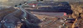 A visualisation of Volvo CE’s Connected Map & Performance Indicator positioning service. (Image: Volvo CE)
The first customers to use CMPI in Asia were from Indonesia, Japan, and Taiwan, said Sweden-based Volvo CE. The product was first launched for North America in 2023.
The tests may be a stategy for the company, as Volvo CE’s annual report noted European net sales overtook Asian net sales in 2023. Sales in Europe were the highest among regions, with North America in second and Asia just behind in third. The company cited downward pressure in the Chinese market as reasoning for the dip in Asia net sales.
What is Volvo’s Connected Map?
CMPI is a positioning service that provides a visualised site overview for all machines and vehicles on a site. That data is then accessible by personnel operating the machines and remotely.
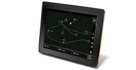 Illustration of the telematics output for Volvo’s Connected Map & Performance Indicator. (Image: Volvo CE)
The programme extracts positioning data from machine telematics or Android/iOS devices with SIM cards and uploads the information to a cloud-based Volvo platform. The software is designed to be compatible with all brands.
A Volvo CE spokesperson said, “‘You can’t be everywhere but your worksite can.’” This [phrase] probably would be the most powerful argument for any customer to explore and use these digital services.”
The real-time transfer of data, Volvo CE said, means project managers can save time, money, and improve on-site safety through immediate response, instead of retrospectively.
Volvo CE said CMPI – and its test run in Asia – have enabled “increased productivity, better fleet optimisation, lower fuel consumption, reduce emissions and improve on-site safety.”
In addition to identifying machines and vehicles, the service can also spot typical jobsite features like roads, load zones, dump zones, speed zones as well as restricted zones.
“Points of interest such as offices, workshops and fuel stations can also be visualized,” said Volvo CE. “Single lane (narrow road) sections can be defined, notifying the operator if another machine is approaching within a single lane section, helping to avoid traffic congestion.”
STAY CONNECTED


Receive the information you need when you need it through our world-leading magazines, newsletters and daily briefings.


CONNECT WITH THE TEAM